In short: we deliver the survey and design inputs a new transmission line and substation need, for utilities, railways and EPC contractors: alternate routes and a feasibility report, a detailed route survey with tower spotting, substation site investigations, and substation drawings.
Route selection
- Desk study on toposheets, satellite imagery, revenue and forest maps
- Three alternate routes flown with drone photogrammetry, so they are compared on current ground conditions
- Comparative feasibility report: length, angle points, crossings, forest, settlements and right-of-way sensitivity, with a techno-economic recommendation
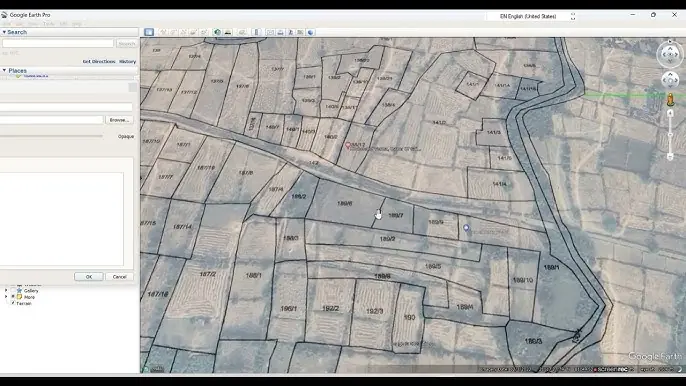
Drone maps on khasra maps
Revenue maps show plot boundaries and numbers but are often outdated. Our drone orthomosaic shows what is on the land today. Superimposed, they show which plots each route and tower would use and whether the land is residential, commercial, agricultural or forest. Land acquisition and right-of-way planning starts from facts, and the best route is easy to see.
Detailed route survey
- DGPS and total station survey of the approved route, with levels and coordinates of every angle point
- Longitudinal profiles and tower spotting to IS 5613 and IS 802
- Tower schedules, crossing schedules and the route alignment plan
- Tree and crop enumeration; LiDAR where clearances under vegetation matter
- LILO and tap-off surveys on existing lines
Substation investigations
- Contour and topographic survey of the substation plot
- Geotechnical investigation: boreholes, SPT, laboratory tests, bearing capacity and foundation recommendations
- Soil resistivity by the Wenner method to IS 3043 for earthing design
- HFL data and the recommended finished ground level
Substation design
- General arrangement drawing (GAD) of the switchyard: bus-bars, transformers, breakers, isolators, CTs, CVTs, lightning arresters, gantries, roads, drains and fire fighting
- GAD of the control and substation building
- Power-supply diagrams and single line diagrams (SLD)
- LT wiring plans, LT SLD and distribution board schedules
- Vetting by IIT, NIT or CPRI where the client requires it
For railway traction
For 2x25 kV railway electrification we also survey and prepare location plans for traction substations (TSS), sectioning posts (SP) and sub-sectioning posts (SSP), and the power-supply diagram that links the grid to the traction network.
Why drones are faster
A conventional ground survey with DGPS and total station measures one point at a time, so a team covers a small area each day and a long corridor takes weeks. A DATA PKT drone team captures around 5 sq km of survey data in a day, which is then mapped and analysed in the office. On a linear corridor such as a highway, one team captures about 35 km of drone imagery for photogrammetry, or about 50 km of aerial video, in a day, and DATA PKT has more than 20 drone pilots (a team of about 22) to put in the field. Ground instruments are still used, but only where they matter most: for the control points that fix the map to real coordinates, for checkpoints that prove the accuracy, and for detail the drone cannot see.
Project example
In Uttar Pradesh we are delivering the survey and design for a 220/132 kV grid substation, its 220 kV and 132 kV lines with three alternate routes each, and location plans for 19 sites. Read the case study.
Once a line is built, we inspect it too: see drone surveys for the power sector and thermal inspection.