Engineering Scale Plans (ESP) and DPR Surveys

We provide drone services, which have become increasingly valuable in the field of railway engineering for various aspects of planning, monitoring, and maintenance. Here’s how our drone data services are helpful in engineering scale planning in railways:

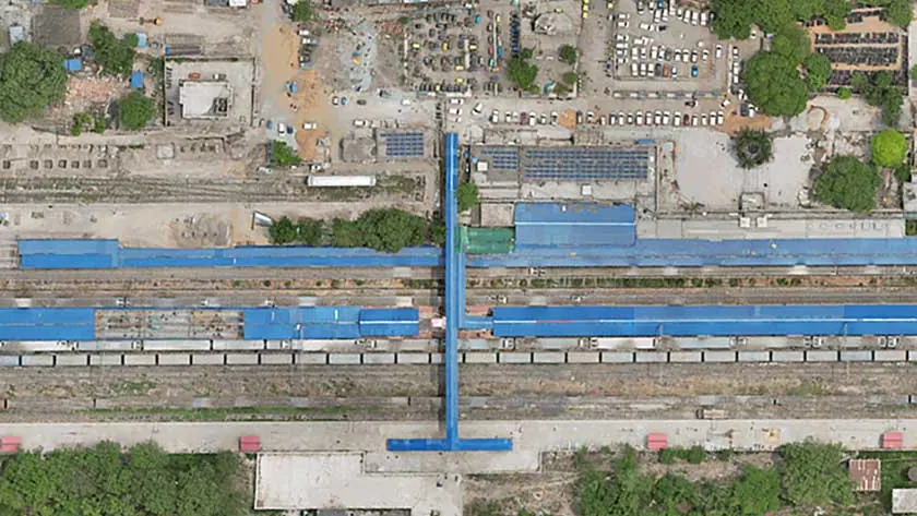
Drone orthomosaic of a railway station yard with platforms and a foot-over-bridge, the base for an Engineering Scale Plan
Surveying and Mapping

Our UAV technology, equipped with high-resolution cameras and LiDAR sensors, can quickly and accurately survey large stretches of railway lines. This data is used to create detailed maps and 3D models of the terrain, which are essential for planning new routes or upgrading existing ones.

Inspection and Maintenance

Our drones can inspect hard-to-reach areas such as bridges, tunnels, and elevated tracks without the need for costly and time-consuming manual inspections. High-resolution imagery and thermal sensors can detect structural issues, track alignment problems, and vegetation encroachment.

Survey drone flying over a railway track for inspection
Aerial view of a railway yard with sidings and sheds
Monitoring Construction Progress

Our uav data enhance safety by reducing the need for personnel to work in hazardous environments. we can inspect areas affected by natural disasters like landslides or floods, providing critical data for risk assessment and mitigation.

Asset Management

Accurate and up-to-date data from UAVs helps in managing railway assets efficiently. This includes tracking the condition of tracks, stations, and other infrastructure, which supports proactive maintenance and reduces the likelihood of service disruptions.

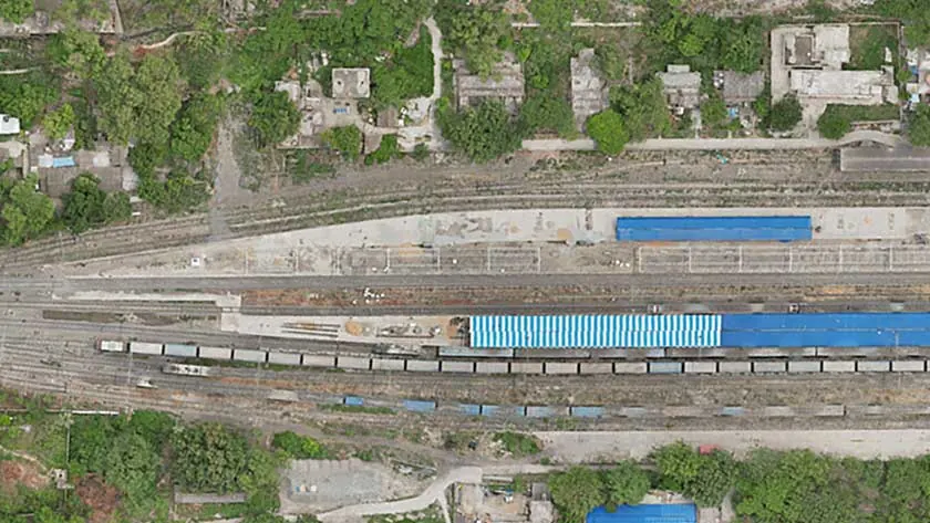
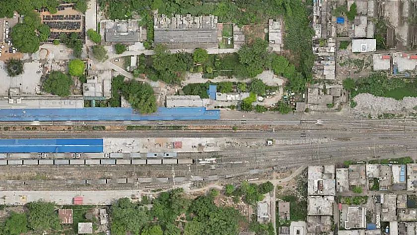
Drone orthomosaic of station tracks, platform sheds and goods wagons used for asset mapping
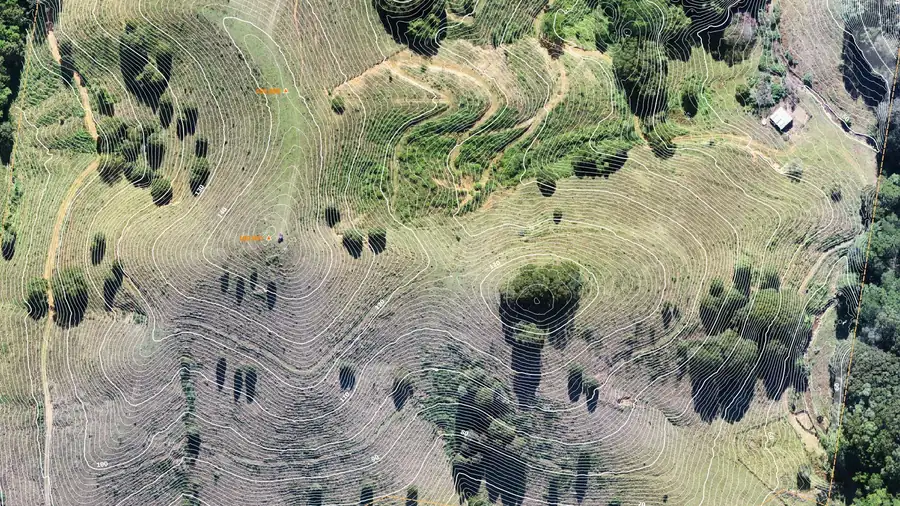
Aerial view of hilly terrain and vegetation captured for a DPR survey
Environmental Assessment

Environmental assessments are crucial for railway projects, especially when expanding networks through sensitive areas. We monitor environmental impact, track changes over time, and ensure compliance with environmental regulations.

Disaster Response

In the event of an accident or natural disaster, our drone service can quickly assess the damage and help in coordinating emergency response efforts. We also provide critical information for decision-making and facilitate rapid recovery operations.

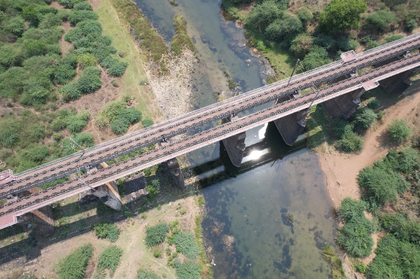
Railway bridge across a river channel, mapped from the air
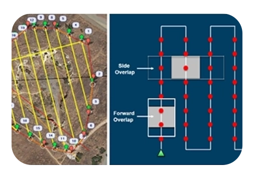
Drone flight plan with ground control points and image overlap for a survey
Cost and Time Efficiency

Using UAVs significantly reduces the time and cost associated with traditional surveying and inspection methods. We cover large areas in a short time, and our data processing capabilities speed up the delivery of actionable insights.

Precision and Accuracy

Advanced sensors and GPS technology enable us to collect precise data with high accuracy. This is crucial for engineering applications where detailed and reliable data is necessary for making informed decisions.

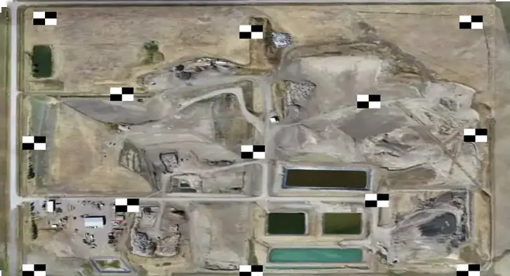
Ground control point targets marked on a drone map for survey accuracy
Drone orthomosaic of the east end of a station yard with tracks, platform and surrounding buildings
Data Integration and Analysis

Our UAV data can be integrated with Geographic Information Systems (GIS) and Building Information Modeling (BIM) for comprehensive analysis and planning. This integration helps in visualizing spatial data and making data-driven decisions.

In summary, our UAV data service supports railway engineering scale planning by providing accurate, detailed, and real-time information that enhances the efficiency, safety, and cost-effectiveness of railway operations and infrastructure development.

What an Engineering Scale Plan shows

An Engineering Scale Plan (ESP) is the railway's master drawing of a station yard or section, drawn to scale with every feature in its true position. Engineering, signalling, traction and operating departments all work from it, and it is the base on which yard remodelling, new lines and other works are planned, checked and approved. An ESP prepared from a drone survey typically shows:

  • Track: running lines, loops and sidings, track centres, and the kilometrage along the section
  • Points and crossings: every turnout with its position and direction
  • Platforms and passenger structures: platform lengths and edges, foot-over-bridges, ramps, shelters and station buildings
  • Crossings of the line: level crossings, road over-bridges and road under-bridges
  • Traction and signalling: OHE masts and portals, signals and cabins
  • Bridges, culverts and drains, with their position on the section
  • Buildings and land: goods sheds, service buildings, quarters, boundary walls and fencing, and the railway land boundary
  • Levels: spot levels and contours for drainage, formation and earthwork

Where railways use ESPs and drone surveys

WorkWhat the survey provides
Yard remodelling and new loop linesThe yard as it stands today, so new layouts fit the space, the structures and the levels
Doubling, third and fourth linesA continuous strip survey of the section, with land, structures and crossings along both sides
Station redevelopmentBuildings, circulating areas, platforms and access roads mapped as one base for the architects and engineers
Cargo terminals and sidingsSite topography, approach alignment and connection to the running line
ROB, RUB and level-crossing worksRoad and rail levels, approaches, utilities and nearby structures
Yard drainage plansGround levels and slopes, existing drains and outfalls, and the disposal point
Land plans and encroachmentsThe railway boundary laid over the orthomosaic, showing what stands on railway land

How we prepare an ESP

  1. Scope and permissions: the yard limits, the chainage and the drawing standard are fixed with the railway, and flights are cleared with the station and the airspace authority.
  2. DGPS control: ground control points and checkpoints are set around the yard and tied to the railway's reference benchmarks.
  3. Drone flights: the yard is captured with overlapping images, and with LiDAR where trees or structures hide the ground.
  4. Processing: the images become an orthomosaic, a surface model and a terrain model with contours.
  5. Ground survey: rail levels, platform heights and details the drone cannot see are measured with DGPS and total station.
  6. Drafting: tracks, turnouts, structures and features are drawn in CAD, in the layers and scale the railway specifies.
  7. Checking and submission: the drawing is verified on site with railway staff, corrected and submitted, with revisions until it is accepted.

What we deliver

DeliverableFormatUsed for
Engineering Scale Plan / yard planCAD (DWG) and PDFPlanning, approval and execution of yard works
Orthomosaic of the yard or sectionGeoTIFFA true-scale picture to check any detail without a site visit
Terrain model and contoursDTM, CAD contoursDrainage, formation levels and earthwork
Longitudinal and cross-sectionsCAD and PDFNew lines, doubling and drainage design
Drainage planCAD and PDFDrains, slopes and the disposal arrangement for the yard
GIS layersShapefile, KMLAsset records and land management

DPR surveys

A Detailed Project Report is only as good as the survey under it. For railway and road DPRs we provide the survey and mapping inputs the consultant and the authority need to fix the alignment, the structures and the cost:

  • Topographic strip survey of the corridor, from drone photogrammetry or LiDAR with DGPS control
  • Alignment options compared on the orthomosaic and terrain model
  • Longitudinal and cross-sections for earthwork and formation design
  • Bridges and drainage: catchments from the terrain model, waterway sections and existing structures
  • Land: the corridor laid over khasra (revenue) maps, showing the land and owners affected
  • Utilities and obstructions: power lines, pipelines, buildings and other features to be shifted or avoided
  • Quantities: earthwork and other quantities measured from the survey data

Why drones for railway yards

  • Safety: the yard is captured from the air, so the survey team spends far less time on or beside running lines.
  • Speed: one drone team captures around 5 sq km of survey data in a day, so a yard is flown in hours rather than surveyed over weeks.
  • Little disturbance to traffic: flights do not need the line, and the ground work left is short and planned with the station.
  • A complete record: the orthomosaic and terrain model stay on file, so later questions can be answered without returning to site.

Accuracy comes from the DGPS ground control and is proved on independent checkpoints. Read more in how accurate a drone survey is and what an Engineering Scale Plan is.

Our railway ESP work

Across two railway divisions we have prepared 93 yard and drainage plans: 61 submitted, and drainage design for 32 yards under way. Read the case study.


Our Features

image – ESP & DPR Surveys
+65000km highway

Already covered 65000+ KM of Highway in a short time span of 3 years and helped project managers and authorities to ensure accountability & increase efficiency.

image – ESP & DPR Surveys
More than 100 KM Highway Per Day

With experienced Pilots, GIS engineers & high-end Survey Drones, we can easily scale up to cover 100 KM of Highway & Roads a day.

About – ESP & DPR Surveys
image – ESP & DPR Surveys
Fast Data Delivery

We have team of GIS expert working around clock to process and analyse the Drone survey data to deliver on or before time.

image – ESP & DPR Surveys
Accuracy

70% more accurate data than the traditional survey

Clientele

Railway authorities we work with include Central Railway, North Central Railway, Eastern Railway, Bridge & Roof Co. (India) Ltd and IRCON International, among other railway and metro organisations.

Central RailwayIndian Railways zone
North Central RailwayIndian Railways zone
Eastern RailwayIndian Railways zone
Bridge & Roof Co. (India) LtdGovernment of India enterprise
IRCON InternationalRailway construction PSU

Frequently asked questions

What is an Engineering Scale Plan (ESP)?

An Engineering Scale Plan is a scaled drawing of a railway station yard or section showing tracks, points and crossings, platforms, buildings and other features in their true positions. Railways use ESPs to plan and approve yard remodelling, new lines and other works.

How does a drone survey help prepare an ESP?

A drone survey with ground control captures the whole yard as an accurate orthomosaic and terrain model in a short time. Drafters then trace tracks, structures and levels from this base, and the field team checks critical details on the ground.

What survey inputs does a DPR need?

A Detailed Project Report usually needs topography of the corridor, existing features and utilities, levels for drainage and earthwork, and land details. Drone, LiDAR and DGPS surveys provide these as drawings and GIS layers.

Does DATA PKT design the project itself?

We provide survey, mapping and design inputs such as drawings and plans. We do not construct projects.

Which railway authorities has DATA PKT worked with?

Our railway clients include Central Railway, North Central Railway, Eastern Railway, Bridge & Roof Co. (India) Ltd and IRCON International, among other railway and metro organisations.

What does an Engineering Scale Plan show?

Tracks and track centres, points and crossings, platforms, foot-over-bridges, level crossings, station buildings and other structures, OHE masts, signals, bridges and culverts, drains, the railway boundary, kilometrage and levels, all in their true positions.

Do you need a traffic block to survey a station yard?

Usually not for the drone flights, which capture the yard from the air. Ground checks of rail levels and details are planned with the station and engineering staff, and kept short.

How accurate is a drone survey for an ESP?

The survey is tied to DGPS ground control points and checked against independent checkpoints, and critical details such as rail levels are measured on the ground. We report the accuracy achieved on the checkpoints with every survey.

In what format are ESPs delivered?

As CAD drawings in the layers and scale the railway asks for, with PDF prints, the orthomosaic, the terrain model and contours, and GIS files on request.