In short: the project needs power for 2x25 kV railway traction. DATA PKT finds three alternate routes for each new line, compares them on maps made from current drone data laid over khasra maps, surveys the approved route in detail, investigates and designs the substation, and prepares location plans for traction substations and sectioning posts.
Scope
| Part | What DATA PKT delivers |
|---|---|
| 220 kV D/C line, state grid substation to the new GSS | Three alternate routes, comparative feasibility report, then detailed survey of the approved route |
| 132 kV D/C line, new GSS to an existing 132 kV line | Three alternate routes with the LILO (loop-in loop-out) point on the existing line, then detailed survey |
| 220/132 kV GSS | Contour survey, geotechnical investigation, soil resistivity, HFL and finished ground level |
| Location plans | 19 sites: the GSS, 4 traction substations (TSS) and 14 sectioning posts (SP) and sub-sectioning posts (SSP) in two sections |
| Design | Power-supply diagram, GSS switchyard GAD, GSS building GAD, LT wiring plan and LT single line diagram, vetted by IIT, NIT or CPRI |
Three alternate routes, compared on current drone maps
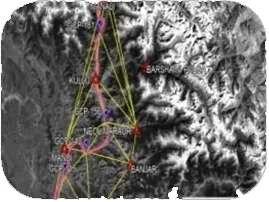
For each line the tender asks for three alternate routes and a comparative feasibility report with a techno-economic recommendation. The usual starting point is Survey of India toposheets, satellite imagery and revenue maps, but these are often years out of date. DATA PKT flies each corridor with drone photogrammetry, so every route is compared on how the ground looks today.
- Route length, angle points and deviation angles
- Crossings: rivers and canals, national and state highways, railways, power lines from LT to 765 kV, telecom and optical fibre
- Forest, settlements and obligatory points
- Right-of-way sensitivity for each alternative
Drone maps on khasra maps: land acquisition made clear
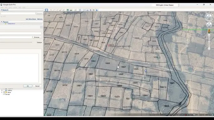
The drone orthomosaic of each corridor is superimposed on the khasra (revenue) maps. The khasra gives the plot numbers; the drone data shows what is on each plot today. Together they show, for every alternative:
- Which plots the line and each tower would fall on
- Whether the land is residential, commercial, agricultural or forest
- Where a small shift in an angle point avoids houses, shops or sensitive land
- The land acquisition and right-of-way picture before the route is approved
That turns route approval from a debate over old maps into a comparison of facts, and makes the land acquisition (LA) work that follows far easier.
Detailed survey of the approved route
- DGPS and total station survey with levelling, and coordinates (X, Y, Z) of every angle and reference point
- Longitudinal profiles (horizontal 1 cm = 20 m, vertical 1 cm = 2 m) with tower spotting and optimisation to IS 5613 and IS 802
- Tower schedules (type, extension, span, deviation angle, chainage, ground level) and the route alignment plan
- Crossing schedules with chainage, crossing angle and clearance
- Tree and crop enumeration along the corridor
Substation investigations and design
At the GSS site DATA PKT carries out a contour survey, boreholes with standard penetration tests and laboratory testing for the geotechnical report, and Wenner four-electrode soil resistivity tests to IS 3043 for earthing design. HFL data and rail levels set the recommended finished ground level.
The design work covers the general arrangement drawing (GAD) of the 220/132 kV switchyard (bus-bars, transformers, breakers, isolators, CTs, CVTs, lightning arresters, gantries, roads, drains and fire fighting), the GAD of the GSS building, the general power-supply diagram of the 220 kV, 132 kV and 2x25 kV network, and the LT wiring plan, LT single line diagram and distribution board schedules. The final GAD is vetted by an IIT, NIT or CPRI.
Location plans for 19 sites
Along the railway, DATA PKT surveys the GSS plot and each proposed traction substation, sectioning post and sub-sectioning post and prepares its location plan with boundary, area, levels, utilities and railway chainage. The 19 sites are the new GSS, 4 traction substations and 14 sectioning and sub-sectioning posts across two sections.

Why drones are faster
A conventional ground survey with DGPS and total station measures one point at a time, so a team covers a small area each day and a long corridor takes weeks. A DATA PKT drone team captures around 5 sq km of survey data in a day, which is then mapped and analysed in the office. On a linear corridor such as a highway, one team captures about 35 km of drone imagery for photogrammetry, or about 50 km of aerial video, in a day, and DATA PKT has more than 20 drone pilots (a team of about 22) to put in the field. Ground instruments are still used, but only where they matter most: for the control points that fix the map to real coordinates, for checkpoints that prove the accuracy, and for detail the drone cannot see.
See the service: transmission line and substation survey and design.